
Early last week the New York Police Department was slapped with a lawsuit alleging that the policies surrounding its body camera program turn the cameras “from an accountability tool into a tool for surveilling and criminalizing New Yorkers.” On Friday, Judge Analisa Torres dismissed the suit as being premature and said the pilot program could move forward.

Two weeks after the collapse of the I-85 bridge, the City of Atlanta launched CommuteATL, an online platform designed to help residents and visitors plan their travel while the I-85 bridge is under construction.
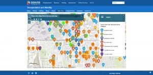
Denver’s crowdsourced data platform asking people to indicate traffic hazards has garnered more than 2,200 responses since its March 6 launch. Sixty-one people were killed in traffic-related deaths on the streets of Denver in 2016. To redress the issue, Denver is participating in Vision Zero, a program where cities use data analytics to prevent transportation-related injuries.

CityGrows is a cloud-based workflow and transparency platform for local governments. With a focus on helping governments transition from paper-based processes to a digital platform, CityGrows improves the experience of interacting with public services for constituents and government employees, while also increasing public access to information about how government works.

Cities need to develop open data policies, but that’s easier said than done. The Sunlight Foundation, a national, nonpartisan, nonprofit organization that uses technology and policy analysis to improve government transparency and accountability, recently released a free Open Data Policy Wizard.

Oakland’s Rent Adjustment Program released a new Web app that streamlined the rental complaint process. The RAP website provides residents with information regarding rent increase laws, their rights as tenants, and the eviction process.

In 2014, New York City Mayor Bill de Blasio launched Vision Zero to end traffic-related fatalities in the city. Three years into the initiative, the mayor’s office released a new report touting how data analytics has helped drop traffic accidents and fatalities to record lows.

New York City’s Tech Talent Pipeline was founded in 2014 to connect New Yorkers with tech jobs and training. Last week, Mayor Bill de Blasio, who created the TTP, announced an expansion of the program with a $1 million investment and new partnerships.
Los Angeles Controller Ron Galperin is giving city residents insight into parking ticket metrics via an open data portal dubbed Street Talk: Parking Tickets in LA.

Mobile devices and geographic information system software were partly responsible for yielding a homeless person census in Aurora, Colo., that was more accurate than the previous year’s count, according to the director of the city’s homelessness program.