Esri has deployed the CrowdRescue Puerto Rico Infrastructure Map, which displays crowdsourced reports about damage from Hurricane Maria affecting the U.S. territory. The map enables a visualization of closed roads, collapsed bridges, flooding, mudslides, areas where communication is unavailable, areas that don’t have power, areas without drinking water, and areas with downed power lines.

Cities including Salem, Ore., and Casper, Wyo., turned to Esri’s Geographic Information System (GIS) technology when thousands of visitors poured in to watch the total eclipse on Aug. 21.

During the process of creating the Colorado Trail Explorer, an interactive open data map providing information on 17,000 trails, Colorado’s Department for Parks and Wildlife sent out a call for information from all 221 of the state’s trail managers. The map, launched on June 2, contains data submissions from 90 of those managers.
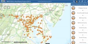
Maryland’s Department of Transportation and State Highway Administration launched e-Road Ready Projects, a live GIS map portraying major projects that have the potential to create congestion.
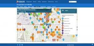
Denver’s crowdsourced data platform asking people to indicate traffic hazards has garnered more than 2,200 responses since its March 6 launch. Sixty-one people were killed in traffic-related deaths on the streets of Denver in 2016. To redress the issue, Denver is participating in Vision Zero, a program where cities use data analytics to prevent transportation-related injuries.

Geographic information system software company Esri has pledged to donate $40,500 worth of data collection and sharing software to winners of the National Institute of Justice’s Research and Evaluation on Drugs and Crime grant program for combating opioid and heroin abuse.

Mobile devices and geographic information system software were partly responsible for yielding a homeless person census in Aurora, Colo., that was more accurate than the previous year’s count, according to the director of the city’s homelessness program.

The Trust for Public Land is launching a platform called ParkServe that will contain urban park data from 13,931 cities and towns across the country, covering more than 80 percent of the population.

Constituents of Cobb County, Ga., who are voting early are able to check their phone and find out how long the wait is at their polling station.

An app designed to help drivers avoid traffic proved helpful during a recent deadly flood. Traffic data from Waze helped government officials and first responders in Louisiana during Baton Rouge’s flooding in August. Esri announced a partnership with Waze and local governments on Oct. 12 to encourage more states and cities to use roadway data for similar projects.
Stay Connected

